Sarpy County Planning & Environmental Linkages Study Findings Released
A planning study to assess the need for and potential location of an additional Interstate 80 interchange in western Sarpy County recommends 192nd Street and Capehart Road as the top potential location for a new interchange.
The Sarpy County Planning and Environmental Linkages (PEL) Study is led by MAPA in partnership with Sarpy County and the cities of Papillion and Gretna.
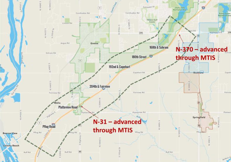
The PEL Study determined a new interchange would help mitigate traffic congestion at the I-80 interchanges at N-31 and N-370, accommodate future growth and development, provide regional connectivity to I-80 and accommodate regional freight traffic.
The study evaluated several possible alternatives along I-80 in western Sarpy County including:
• Pflug Road
• Platteview Road
• 204th St. & Fairview Rd.
• 192nd St. & Capehart Rd.
• 180th Street
• 168th St. & Schram Rd.
The Metro Area Travel Improvement Study that MAPA conducted with the Nebraska Department of Transportation (NDOT), and released in 2017, identified the N-31 and N-370 interchanges on I-80 for improvement among other interchanges.
“As the communities in our region continue to grow, we need to plan for transportation investments that coordinate with local development,” said Mike Helgerson, MAPA Executive Director. “We look forward to working with our Sarpy County partners and NDOT to help move this work forward.”
Sarpy County Planning & Environmental Linkages (PEL) Study project page
A PEL study is a high-level planning process that considers environmental, community and economic
goals early in project development and carries them forward through the environmental decision-making
process to design and construction.