Sarpy County I-80 Planning and Environmental Linkages Study
BackThe Omaha-Council Bluffs Metropolitan Area Planning Agency (MAPA), in coordination with Sarpy County and the Cities of Gretna and Papillion, is developing the Sarpy County I-80 Planning and Environmental Linkages (PEL) Study. The planning process began during summer 2020 and was completed in early 2023.
Final Report Documents
- Final Report (Low Resolution Graphics for reduced file size)
- Final Report (High Resolution)
- Appendix A: Federal Highway Administration (FHWA) PEL Questionnaire
- Appendix B: Previous Report Summaries
- Appendix C: Land Use Planning
- Appendix D: Traffic Operations
- Appendix E: Public Outreach
- Appendix F: Agreement Between Sarpy County and the State of Nebraska
- FHWA Acceptance Letter
The map below shows the area considered by this study. The Environmental Review Area includes all of western Sarpy County and was used to collect relevant social, economic, and environmental data. The Alternatives Study Area has been centered along I-80 from just west of Pflug Road to just east of the N-370 interchange. The Alternatives Study Area also includes a small buffer both north and south of I-80 to encompass any necessary roadway connections.
BACKGROUND
The concept of a PEL study is to bring together the planning efforts conducted up to and during this stage and to integrate them into the environmental documentation process, or NEPA, and to help make that transition as smooth as possible. NEPA is a strict process law and requires certain protocols to be followed during project development, alternatives screening, and evaluation of impacts. A PEL study offers a little more flexibility in the planning process, yet still requires enough detail to be gathered and considered.
The results of this PEL will inform, direct, and assist the NEPA process and decision makers when it comes to pursuing specific projects identified during the PEL process. The PEL process is particularly useful when the number and/or types of projects are unknown, the costs or potential resources are unknown, and the funding sources or impacts are unknown. The PEL process can help identify these unknowns, direct decision makers to the appropriate NEPA document, and begin to lay the framework for avoiding impacts and identifying funding sources.
Previous Study Review & Land Use Planning
The project team completed an extensive review of past related studies, which informed and shaped the first public input held in 2021. The project team then engaged key stakeholders and developed a future land use scenario. In coordination with the project core team, possible transportation alternatives were identified and analyzed for their suitability given future traffic growth to establish a range of reasonable alternatives.
Public Input Period #1
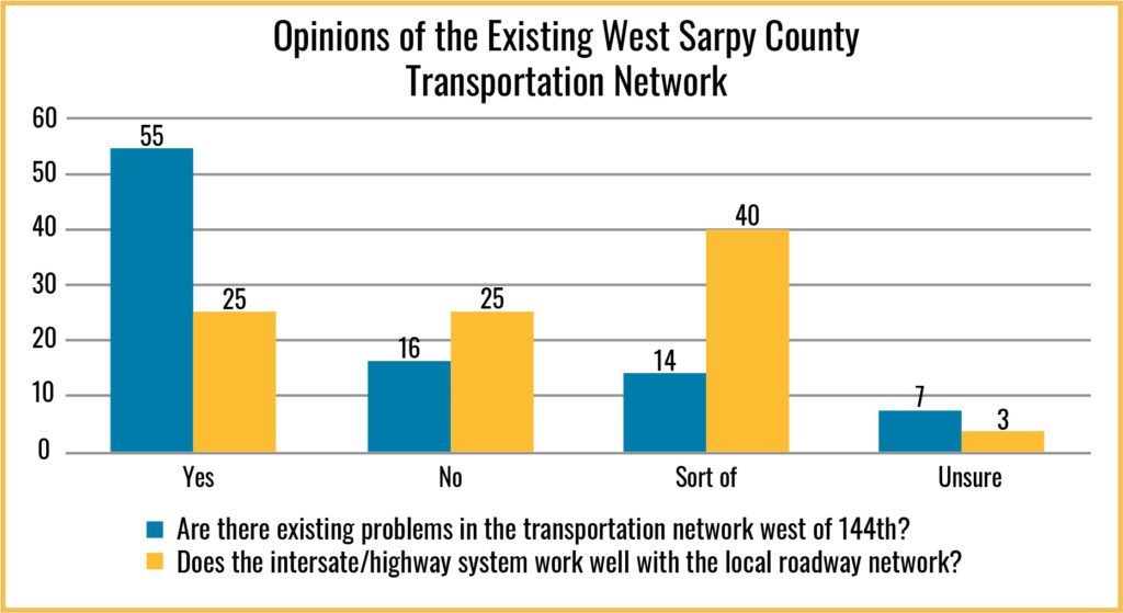
The first public input period was conducted from July 4th to August 20th, 2020. This survey looked to better understand the traveler types, destinations, trip purpose, and a general assessment of the suitability of the existing network. A highlight of the results from the 93 survey respondents are listed below.
Input and Conversation focused on:
- Problems in the existing transportation network, such as traffic backups during rush hours on Highway 370 and I-80.
- The need for east-west and north-south routes.
- The importance of transportation options and whether or not the interstate/freeway system works well with the local roadway network.
- The impact roadway improvements may have on Gretna, Papillion, and Springfield.
Existing and future development, including its challenges and opportunities, municipal and county plans for growth, areas that could be served by utilities, and environmental considerations.
Public Input Period #2
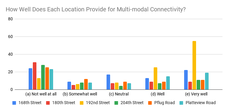
In the second public comment period, respondents were provided detailed information on the six proposed project alternatives and asked questions about each alternative’s acceptability. The interactive website included drone video, narrative description, and a mapping tool to help users provide their response. Overall, 1,811 individual survey responses were logged, with over 2,000 users accessing the survey homepage during the survey period from July 14 to August 10, 2022.
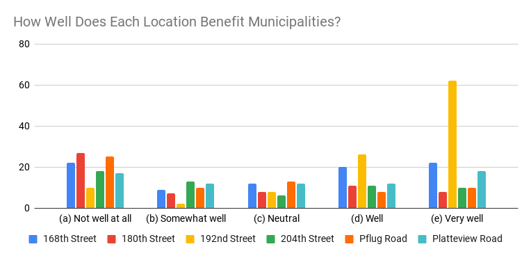
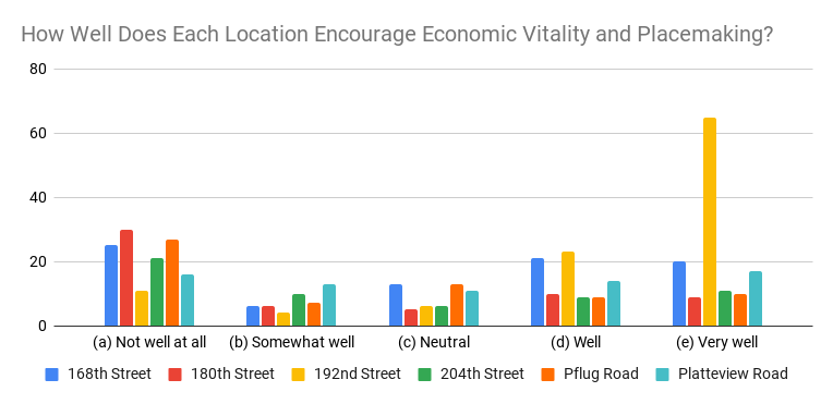
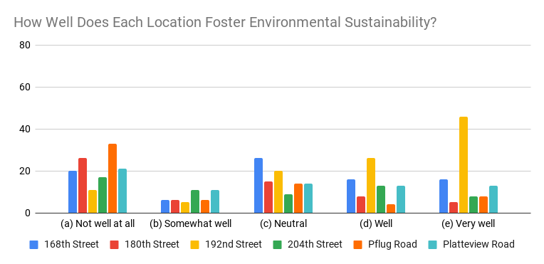
These survey results were combined with performance data and together comprise the performance and acceptance criteria used for alternative screening.
CONTACT US
Jim Boerner
MAPA Transportation Planner
402-444-6866 x3231
transportation@mapacog.org