The Omaha-Council Bluffs Metropolitan Area Planning Agency (MAPA), in coordination with Sarpy County and the Cities of Gretna and Papillion, is developing the Sarpy County I-80 Planning and Environmental Linkages (PEL) Study.

The study will evaluate the need for a transportation improvements along I-80 from Pflug Road overpass to the south to the Nebraska Highway 370 interchange to the north. Once the study is completed, future work may involve preparing National Environmental Policy Act (NEPA) documents, an Interchange Justification Report (IJR), design, and construction.

The overall purpose and need in the Study Area will be addressed by the proposed improvement strategies. Specific project needs, along with several additional project goals, will be used to develop, analyze and compare the various alternative strategies.

Environmental Review & Alternatives Study Area

The Environmental Review Area includes all of western Sarpy County and was used to collect relevant social, economic, and environmental data.

The Alternatives Study Area has been centered along I-80 from just west of Pflug Road to just east of the N-370 interchange. The Alternatives Study Area also includes a small buffer both north and south of I-80 to encompass any necessary roadway connections.

We Need Your Input

Through data analysis and public input, a series of alternatives have been identified. Each responds to the transportation needs within the study area. On each of these pages you will find information about the alternative and have the opportunity to provide your feedback. Please review each of the following locations:


Frequently Asked Questions

What is the purpose of this study?

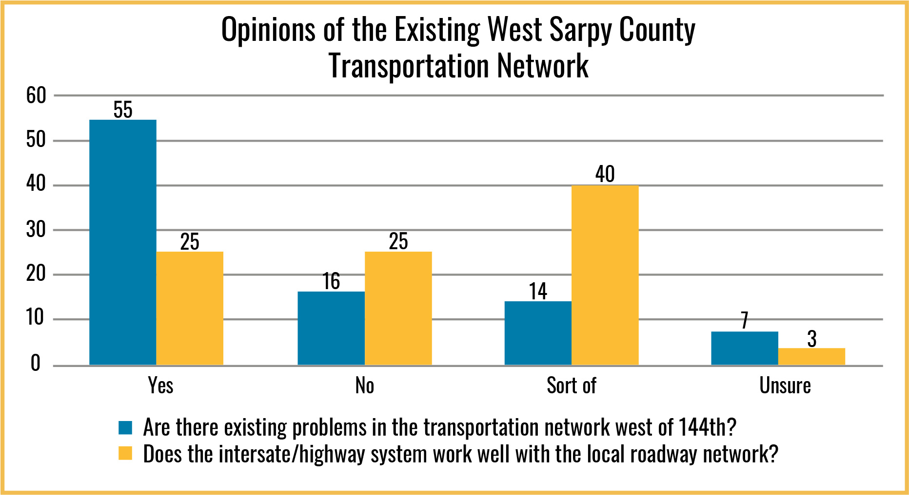
The two existing interchanges along I-80 at N-370 and N-31 are experiencing unacceptable traffic levels of service (LOS), which are projected to get worse over the course of the next several years. In addition, Sarpy County is experiencing tremendous growth and its population is expected to increase exponentially as new land becomes available. Previous studies, such as the Metro Area Travel Improvement Study (2015-2019), have documented the current and forecasted traffic deficiencies at both the N-370 and N-31 interchanges with I-80.

Current and future development planned in western Sarpy County will continue to impact the operations and capacity of the existing interchanges and could influence the possible alternatives developed to address these issues. The Sarpy County I-80 PEL will accomplish three overarching goals:

  1. Identifying the overall project purpose and specific needs to help develop and screen each of the identified alternatives
  2. Working with area stakeholders to develop a combined land use vision for the future of the study area
  3. Evaluating a broad range of alternative strategies, including the rationale for determining both the reasonableness of the alternative(s) carried forward and the reasoning for eliminating any of them.


What is the Study Area?

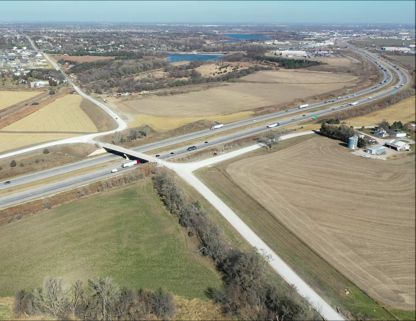
The environmental review area encompasses western Sarpy County west of Nebraska Highway 50 (N-50). The alternatives review area extends along Interstate 80 (I-80) from just west of Pflug Road to Nebraska Highway 370 (N-370) and a buffer approximately one mile out from the interstate to address any necessary roadway connections.


What is a Planning and Environmental Linkages (PEL) study and why is it necessary?

A PEL Study is a high-level planning process that considers environmental, community, and economic goals early in project development and carries them through the environmental decision-making process (National Environmental Policy Act), design and construction. The Sarpy County I-80 PEL brings together the planning efforts conducted up to and during this study and integrates them into the environmental documentation process, or NEPA, and helps make the transition between studies as smooth as possible.

In addition, NEPA is a strict process law and requires certain protocols to be followed during project development, alternatives screening, and evaluation of impacts. A PEL study offers a little more flexibility in the planning process, yet still requires enough detail to be gathered and considered. The results of the PEL can inform, direct, and assist the NEPA process and decision makers when it comes to pursuing specific projects identified during the PEL process. The PEL process is particularly useful when the number and/or types of projects are unknown, the costs or potential resources are unknown, and the funding sources or impacts are unknown. It can also help identify the unknowns, direct decision makers to the appropriate NEPA document, and begin to lay the framework for avoiding impacts and identifying funding sources.


Who is participating in the study?

The Study is being led by MAPA and its local partners, Sarpy County, and the Cities of Gretna, and Papillion. The Study is also being led by NDOT and FHWA. Numerous additional local, state, and federal agencies and groups have been solicited for input and have been involved in the development of information for the study. The key players who are listening for input from you are MAPA, NDOT, FHWA, Sarpy County, and the Cities of Papillion and Gretna.


What are the major elements of the study?

The Sarpy County I-80 PEL began during 2020 and will continue through summer 2022. Key elements involve engaging the community and coordinating with a Community Advisory Group, Core Team, and Technical Advisory Group throughout the study. Developing a Purpose and Need Statement, crafting growth and development scenarios that would help inform practicable alternatives, screening of alternatives, and drafting initial and final drafts of the study document are also important parts of the PEL process.


Will construction begin soon?

At this time, no funding is available for design and construction of a new interchange(s), but continued planning is necessary for the future improvement of I-80 in Sarpy County if and/or when funding becomes available. Potential next steps could involve further development of one or more project proposals, securing funding, preparation of an Interchange Justification Report (IJR), preparation of an Environmental Assessment (EA), Environmental Impact Statement (EIS), or Categorical Exclusion (CE) in compliance with the National Environmental Policy Act (NEPA), preliminary engineering, environmental studies and field investigations, surveying, land acquisition, final design, and construction. Land acquisition would follow state and federal guidelines.


Who do I contact for more information?

For questions about the PEL study please contact Jim Boerner at jboerner@mapacog.org or (402) 444-6866 x 3231.

For more information about ongoing road construction in Sarpy County please see the CONNECTSarpy website.

For information on the Metropolitan Area Transportation Improvement Study (MTIS) please refer to this website.


The Planning Process

This study, led by MAPA, was implemented in close coordination with a Community Advisory Group (CAG) that included representatives from Sarpy County and the cities of Papillion and Gretna, adjacent muncipalities, relevant public and private entities, and the Nebraska Department of Transportation.

The CAG provided comments and input on project planning and approved project deliverables, such as the project Purpose and Need, future land use, and alternative screening criteria.

The project team has developed a list of practicable alternatives and screening criteria since the project began in the Summer of 2020.


Summer - Winter 2020

Purpose & Need
Data Collection & Analysis
CAG Meeting
Public Input
Land Use Analysis

Initial Range of Alternatives
 

Winter 2020 - Spring 2022

Alternatives
Traffic Study
Land Use Scenarios
CAG Meeting
Public Input

Practicable Alternatives & Screening Criteria

Summer - Winter 2022

Recommendations
Final PEL Report
NEPA Transition Plan
PEL Questionnaire


Final PEL Study with Transition Plan


What We've Heard

Community engagement for the Sarpy County I-80 PEL Study began during summer 2020 and will continue through fall 2022. As part of the process, the planning team:

  • Interviewed stakeholders representing Nebraska Department of Transportation, Sarpy County, Gretna, Papillion, Springfield, utility providers, economic development groups, and the Sarpy County and Sarpy Cities Wastewater Agency.
  • Met with the Community Advisory Group and Technical Advisory Group.
  • Gathered feedback from area residents, workers, property owners, employers, government staff and officials, and other stakeholders via an online public meeting and opinion survey.

Input and Conversations Focused On:

  • Problems in the existing transportation network, such as traffic backups during rush hours on Highway 370 and I-80.
  • The need for east-west and north-south routes.
  • The importance of transportation options and whether or not the interstate/freeway system works well with the local roadway network.
  • The impact roadway improvements may have on Gretna, Papillion, and Springfield.
  • Existing and future development, including its challenges and opportunities, municipal and county plans for growth, areas that could be served by utilities, and environmental considerations.

Purpose and Need

The two existing interchanges along I-80 at N-370 and N-31 are already experiencing unacceptable traffic levels of service (LOS) which are projected to get worse over the course of the next several years. Sarpy County is already experiencing tremendous growth and that growth is expected to increase exponentially as new land becomes available.

The Sarpy County I-80 PEL Study identifies the following project needs that arise because of these conditions:

Mitigate Deficient Traffic Operations
Relieve N-370 Volumes

N-370 has been experiencing increasing congestion for several years and the amount of traffic at the I-80 interchange continues to increase with recent development activities in the area. The N-370 interchange was studied previously as part of the MTIS study which reported that the interchange levels of service will continue to degrade over the next twenty years. As part of this study, a TDM analysis was completed for the proposed interchange locations. To meet this performance criteria, projects coming out of this study should reduce N-370 traffic and help improve the overall traffic operation of the interchange. The amount of traffic volume difference for each alternative was compared to the base travel demand model with only the N-370 interchange in order to demonstrate any reductions or increases.

Relieve N-31 Volumes

Similar to N-370, N-31 has experienced an increase in traffic volumes at the interchange with I-80. The N-31 interchange provides west Omaha traffic an option to use US Highway 6/N-31 through Gretna to access the western edge of Omaha, or vice-versa for traffic coming from west Omaha that wants to travel west on I-80. The N-31 interchange was studied previously as part of the MTIS study which reported that the interchange levels of service will continue to degrade over the next twenty years. As part of this study, a TDM analysis was completed for the proposed interchange locations. To meet this performance criteria, projects coming out of this study should reduce N-31 traffic and help improve the overall traffic operation of the interchange. The amount of traffic volume difference for each alternative was compared to the base travel demand model with only the N-31 interchange in order to demonstrate any reductions or increases.

Provide Regional Connectivity
Reduce Indirect Travel (VMT)

The addition of a new interchange along I-80 in between the existing N-31 and N-370 interchanges should reduce the amount of indirect travel for drivers wishing to access I-80 from the north in west Omaha and from elsewhere within Sarpy County. The indirect travel was measured using MAPA’s TDM that was adjusted with the proposed land use identified through the planning efforts from this study. The measure of effectiveness (MOE) unit used for the comparison of alternatives is the amount of vehicle miles traveled (VMT) in the travel demand model. The VMT for each interchange location was compared the base scenario that includes only the N-31 and N-370 interchanges.

Reduce Congestion (VHT)

The addition of a new interchange along I-80 in between the existing N-31 and N-370 interchanges should reduce congestion along the N-31 and N-370 corridors. Congestion within the interchanges of N-31 and N-370 were not analyzed on a typical capacity analysis level because both interchanges were analyzed in the MTIS study which provided geometric modification recommendations for each interchange. For this study, the measure of effectiveness unit used for the evaluation of alternatives is the reduction in vehicle hours traveled (VHT). VHT is a unit that is a commonly used MOE that is directly pulled from the Travel Demand Model. VHT is the measurement of time a vehicle travels along a link or waits to access a link. The VHT from the travel demand model is a total for the links within the model. The VHT for each interchange alternative was compared the base travel demand model scenario that includes only the N-31 and N-370 interchanges.


Partner Agencies


Contact Us

Jim Boerner
MAPA Transportation Planner
402-444-6866 x3231
jboerner@mapacog.org